Upcoming Event Tech Maven Geospatial Speack at GEOINT SYMPOSIUM in St Louis Missouri

Announcing the Release of Print Map

Announcing the Release of Print Map

Print Map- Version 1.0.0 launched on Google Play Store for Android.

http://printmap.online/

Print Map is used for preparing offline high quality georeferenced PNG maps and PDF from custom vector tile basemaps (OpenMapTiles and MapBox) with custom configurable stylesheets.


Easily Export High Quality Maps from a mobile app
Set initial view by searching or entering Lat Long

Choose Output format (PNG or PDF)

Select a Map Style based on either MapBox or OpenMapTiles Vector Tile Basemaps and Satellite Imagery

Set your page size and DPI

The PNG Images can optionally include PGW -Worldfile and PRJ-Projection sidecar files that are recognizable by all GIS Mapping Software packages and many mobile apps. The PNG images can also be inserted into reports and documents.

Announcing the Release of Tile Server

Announcing the Release of Tile Server

Tile Server – Version 1.0.0 launched on Google Play Store for Android.

https://techmaven.net/portabletileserver/

Serve Map Tiles (XYZ or WMTS) URL’s to mapping clients/apps/software or to advanced map viewer.
From MBTILES or GPKG (GeoPackage) SQLite Databases/files that contain raster tiles, vector tiles, elevation/terrain tiles, other tile data in the tile_data blob.


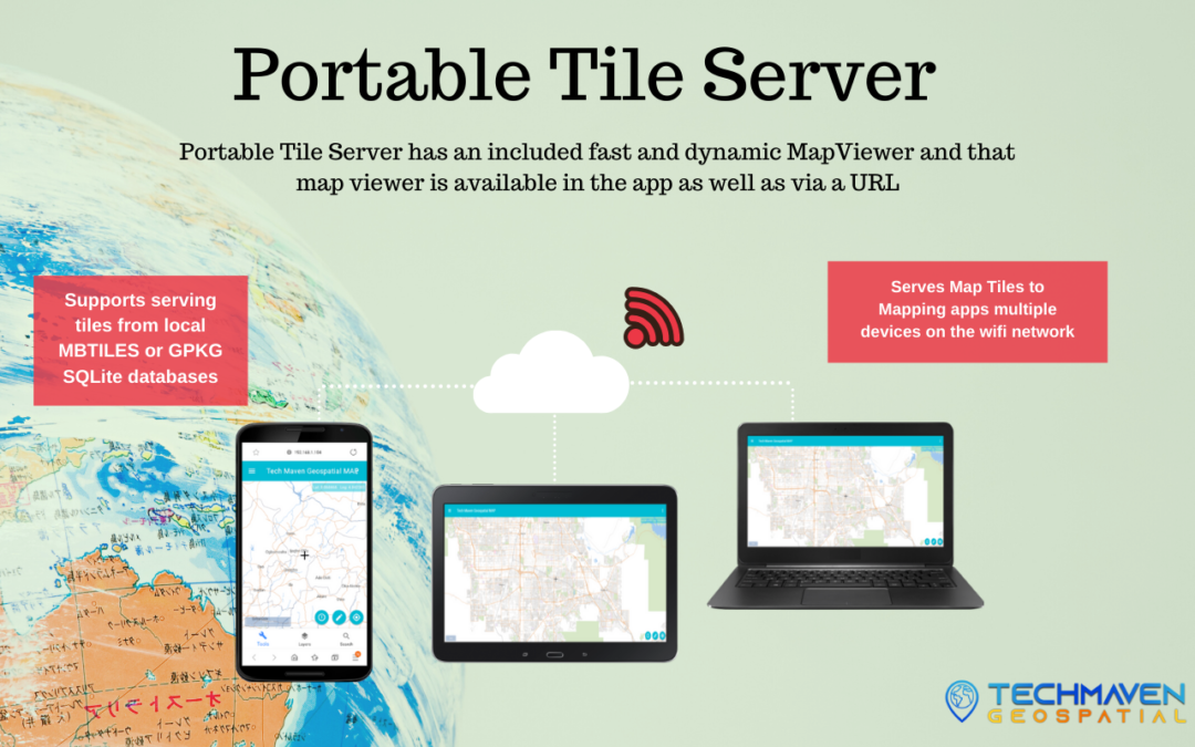
Serve Static Geospatial Data (GIS) files like KML/KMZ, GeoJSON, CSV, GPX, CZML, SHP, 3DTiles, 3DModels (gltf/glb) and others. This is basically a file server that any file type including zip file has an endpoint and accessible for streaming or downloading across the network.

Discover-able Endpoints and webpages
WiFi turned on is required to run this app and have it get an IP Address from the network.
This is a local IP Address NOT internet accessible. So only users on your local network can access this data.

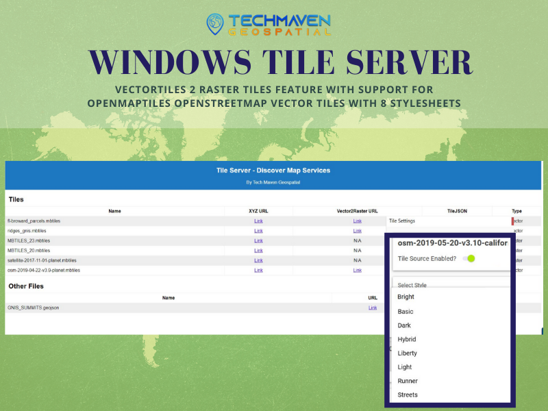
ipaddress:8080/discover – web page listing of all the tile layers and static files
ipaddress:8080/services – JSON response and access to tile.json for each layer
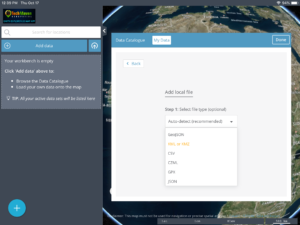
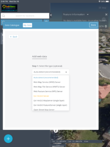
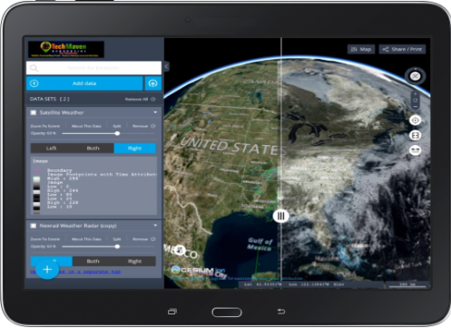
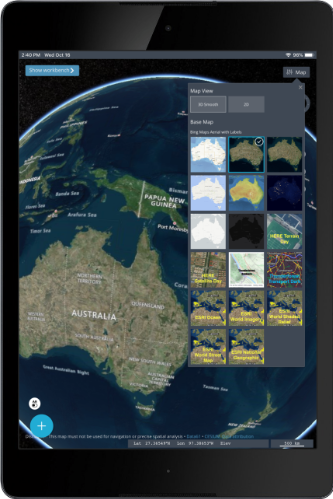
ipaddress:8080/map – advanced map viewer with quick access to tile layers and adding local Shapefiles, GPKG, GeoJSON, KML, GPX, CSV
ipaddress:8080/wmts – XML getcapabilities response

The app also features a tile details view of each tile service. That includes data from the metadata table and the URL’s and TileJSON

The app can serve data to other apps or desktop/laptop GIS mapping software on the network. ArcMap and ArcGIS Pro can access it via OGC WMTS.

Other mapping clients or apps can use the Standard XYZ Tile Server URL (like : http://ipaddress:8080/getGPKGRasterTile/name/{z}/{x}/{y}.png or http://ipaddress:8080/getMBTilesRasterTile/name/{z}/{x}/{y}.png

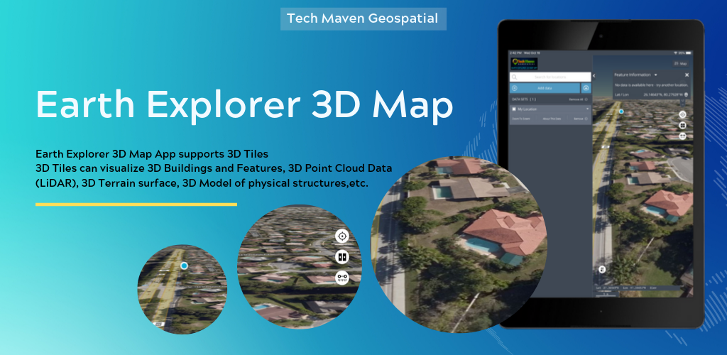
The Map is accessible on the same device (phone/tablet) or from any device/computer on the network. The Map supports digitizing/drawing, has OSM vector tile basemaps with a style picker, raster basemap selector, supports adding mapping service URL’s like Raster Tiles, Vector Tiles, WMS and others.The map offers in-app dynamic vector tiling of loaded vector data for optimized handling of large data.
Digitize and Draw/Create data and perform Analysis. Tools like Measure distance and area, show coordinates in multiple formats.

The app is perfect for sharing data among devices so one device loads all the map tiles and nearby devices can stream it. This could be in response to a natural disaster or other event and a mobile command center is setup and this becomes the map server for sharing data.

Notes:
GeoPackage Raster Tiles should only be 3857 Spherical Web Mercator /Auxillary Web Sphere Spatial Reference System/Projection. Test at your own risk support for others.

MBTILES must have the required tiles table or view and metadata table and should follow 1.2 or 1.3 specification.
Encrypted SQLite Databases (SQLCipher or other approaches ) are NOT supported.

We’ve tested the tile server with both web and desktop mapping software (QGIS Desktop, Global Mapper, UDIG, ESRI ArcMap, ESRI ArcGIS Pro, GeoMedia, Autodesk AutoCAD Map, Manifold, MapInfo, Kongsberg Geospatial Mapping Engine(s), GRASS, and others.)

Announcing the Release of Earth Explorer 3D Map

Announcing the Release of Earth Explorer 3D Map

Earth Explorer – Version 1.0.0 launched on Google Play Store for Android.

http://earthexplorer.world

Earth Explorer is a 3D Globe with Augmented Reality (Control View with your device’s sensors GPS/GNSS, Accelerometer, Gyroscope, Compass, other).

Users can load local vector data to the map.Supported formats are:

  • GeoJSON,
  • KML/KMZ,
  • GPX,
  • CZML,
  • CSV – Comma Separated Value Text file – with Latitude and Longitude or with known column/field names like state, zipcode,country and other regional mapping fields
  • JSON Catalog files – data layers defined in a JSON file.

Users can load online mapping services:

  • ESRI Dynamic REST Mapping Services (MapServer, FeatureServer,ImageServer)
  • OGC Mapping Services (WMS, WFS, WCS, WMTS)
  • Raster Tile Servers – XYZ URL
  • Vector Tile Server – XYZ URL

If users have Vector Data in other formats, they can upload to our server and have it converted and sent back to app/map as GeoJSON.

Features:

  • Measure Linear and Area
  • Search and Geocode
  • Raster Tile Basemap Picker – uses BING
  • Maps, Open Street Map, CartoDB
  • Basemaps, Stamen Basemaps, ESRI Basemaps
  • Split/Map Swipe to compare layers
  • Switch map between 3D Terrain, 2D or 3D Smooth
  • Geolocation show your location on the map
  • Tilt Map
  • Rotate Map
  • Table of Contents and Map Legend and ability to re-order data layers by dragging
  • Displays Coordinates in Lat Long or UTM
  • Drop Markers
  • Copy Lat Long
  • Ability to download tables from data loaded
  • Zoom to Extent of Data
  • Charting
  • Timeslider on Spatialtemporal datasets
  • Export/Print PNG/PDF of Map
  • Share Link and Embed code
  • View Metadata (data about data)
  • Re-Order Table of Contents Items
  • Search CKAN/CSW/SOCRATA OpenData
  • Sites if Catalog file imported
Windows Tile Server

Windows Tile Server

Windows Desktop Application with installer for easily configuring a machine as a tile server for on the same machine access or access to data across a local network.With advanced feature vector tiles2 raster tiles and advanced mapviewer.


Serves MBTILES Raster Tiles

Serves MBTILES Vector Tiles

Serves GPKG Raster Tiles

Serves OpenMap Tiles OpenStreetMap Vector Tiles as Raster Tiles

Tile URL’s available as Standard XYZ  or OGC WMTS

Discover Webpage endpoint

Services JSON response endpoint

get capabilities WMTS endpoint

Advanced MapViewer endpoint

Static file hosting/serving


more information can be found at:

https://techmaven.net/portabletileserver/

error: Content is protected !!