Upcoming Event Tech Maven Geospatial Speack at GEOINT SYMPOSIUM in St Louis Missouri

Vector Tiles to Raster Tiles Desktop App

Vector Tiles to Raster Tiles Desktop App

Vector Tiles to Raster Tiles

Desktop App 

(Windows, Linux, and MacOSX)

App Information:

Converts PBF Vector Tiles URL (this can come from the internet or from Geo Data Server https://geodataserver.techmaven.net/ ) with Stylesheet to PNG Raster Tiles (Folder of XYZ or MBTILES SQLite)

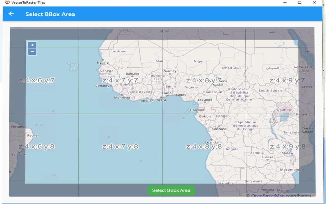
Define your area of interest (BBOX/BOUNDS) and your Min and Max Zoom Level Range

Works as a background process – enables multiple jobs to run simultaneously.

Works with basemap vector tiles data from multiple providers:

  • Tech Maven Geospatial OSM Vector Tiles and styles
  • MapTiler Data 
  • MapBox
  • ESRI
  • HERE Maps

Supports Overlays Vector Tiles

Supports styles with multiple sources (topo/terrain style with contour lines and hillshade or satellite hybrid style or other combination of data)

Vector to Raster Downloading

View Folder WebBrowser

Why is this valuable?

Worldwide OSM Vector Tiles is about 80 GB however many mapping applications don’t support vector tiles or complex vector tiles. This allows you to pre-cache an area of interest such as Raster Tiles.  

Users of apps like ATAK, WINTAK, iTAK, and MCH can now have data they can consume.

Users of On-Premises or Edge Mapping /Common Operating Picture Solutions can now have rich basemap data available.

Damage Assessment Mapper  iOS & Android App

Damage Assessment Mapper iOS & Android App

Damage Assessment Mapper

iOS & Android App


Easily collect Damage Assessments for Buildings and Structures (following the Applied Technology Council specification ATC-45 Rapid Evaluation Safety Assessment Form

View Data collected on the Map

View the Attribute Table of collected data and local GeoPackage and SQLite databases with a search

View supporting reference documents such as PDF, EPUB, WebPages, Files (docx, xlsx), Photos, and text notes in a resizable widget

Create ad-hoc forms for rapid data collection with an in-app or web form designer.

PDF report Created from Collected Data

Create Reports (PDF) of collected data Easily share collected data in many formats

Create and edit/digitize GeoJSON and add attributes
Measure linear and
area distances
Create Placemarks
Search

View SQLite and GPKG vector features attribute Table and GeoJSON properties

Export Collected data to CSV

Convert Vector 

Convert Vector GIS Data to offline optimized formats with an In-app converter or TMG Vector Conversion API (screen to submit jobs in-app)

Converts Local FileGDB, PersonalGDB, Shapefiles, GPKG, KML/KMZ, MapInfo, and other formats to GeoJSON or MBTILES vector Tiles

Form View →

View Collected data

View Attribute/table Grid

 and Perform Searching

Basemaps (online or offline osm vector tiles)

Load Local Offline Map Data

  • MBTILES

  • GPKG

  • GeoJSON

      Save map configuration (JSON Catalog)

      Load catalogs (share catalogs connected to online/internet data layers

      XYZ Raster Tiles, GeoJSON URL

      Vector Tiles and coming soon WMS)

      View Attributes of Map Data 

      Catalog Management

      Go to Coordinate

      Convert Coordinates

      View Coordinates including

      Lat Long Decimal Degrees and DMS, MGRS -Military Grid Reference System (same as US National Grid), GARS- Global Area Reference System

      GPS Tracker (GPX Recorder)

      Range Rings  

      3D Terrain

      Offline 3D Terrain is supported by MapBox Terrain-RGB or MapZen Terrarium PNG

      Background Record Tracks (breadcrumb trail)

      Route Planning and Route Widget

      Create custom ad-hoc forms (offline)

      Design in-app or website https://mapdata.xyz/form_generator

      2nd Resizable Widget

      • Office Documents (Word, Excel, other)

      • Photo Viewer

      • PDF Viewer

      • EPUB Viewer

      • User Links WebPages (save a configuration of commonly accessed pages open in-app)

      • File Manager

      • Wifi Sharing – access files from other devices

      Share location – click on top widget native share appears

      error: Content is protected !!