
Vector Tiles to Raster Tiles Desktop App

Vector Tiles to Raster Tiles
Desktop App
(Windows, Linux, and MacOSX)

App Information:
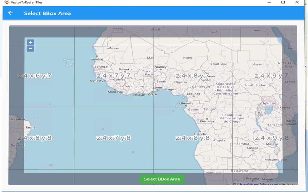
Converts PBF Vector Tiles URL (this can come from the internet or from Geo Data Server https://geodataserver.techmaven.net/ ) with Stylesheet to PNG Raster Tiles (Folder of XYZ or MBTILES SQLite)
Define your area of interest (BBOX/BOUNDS) and your Min and Max Zoom Level Range
Works as a background process – enables multiple jobs to run simultaneously.
Works with basemap vector tiles data from multiple providers:
- Tech Maven Geospatial OSM Vector Tiles and styles
- MapTiler Data
- MapBox
- ESRI
- HERE Maps
Supports Overlays Vector Tiles


Supports styles with multiple sources (topo/terrain style with contour lines and hillshade or satellite hybrid style or other combination of data)

Vector to Raster Downloading

View Folder WebBrowser

Why is this valuable?
Worldwide OSM Vector Tiles is about 80 GB however many mapping applications don’t support vector tiles or complex vector tiles. This allows you to pre-cache an area of interest such as Raster Tiles.
Users of apps like ATAK, WINTAK, iTAK, and MCH can now have data they can consume.
Users of On-Premises or Edge Mapping /Common Operating Picture Solutions can now have rich basemap data available.
Map Discovery Windows
New Windows Advanced Mapping App Map Discovery
https://mapdiscovery.techmaven.net/windows/
It’s the perfect app for your Vehicle/Rig mounted computer or laptop. Easy to use – rapidly consume and connect to online and offline data via Catalog (JSON) data loading. Supports full advanced editing and data creation offline via GeoJSON and Online/Connected with OGC WFS-T (and coming soon ESRI GeoServices REST API FeatureServer ). It’s got User Links feature for web pages that you may need to access resizable windows (json configuration of web pages) . Supports Attribute table with search.
This is a powerful feature rich app ready for real work!
Geospatial Data Servers
Tech Maven Geospatial is proud to release
https://medium.com/@geospatialsolutions/geospatial-data-servers-dc09b3622018
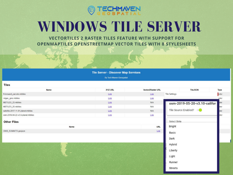
Windows Tile Server
Windows Desktop Application with installer for easily configuring a machine as a tile server for on the same machine access or access to data across a local network.With advanced feature vector tiles2 raster tiles and advanced mapviewer.
Serves MBTILES Raster Tiles
Serves MBTILES Vector Tiles
Serves GPKG Raster Tiles
Serves OpenMap Tiles OpenStreetMap Vector Tiles as Raster Tiles
Tile URL’s available as Standard XYZ or OGC WMTS
Discover Webpage endpoint
Services JSON response endpoint
get capabilities WMTS endpoint
Advanced MapViewer endpoint
Static file hosting/serving
more information can be found at:

Windows Data Tester App
Tech Maven Geospatial, LLC is proud to announce our new Map Data Tester/Explorer Desktop App.
It’s a Windows 10 UWP app based on ESRI ArcGIS Runtime SDK for .NET C#
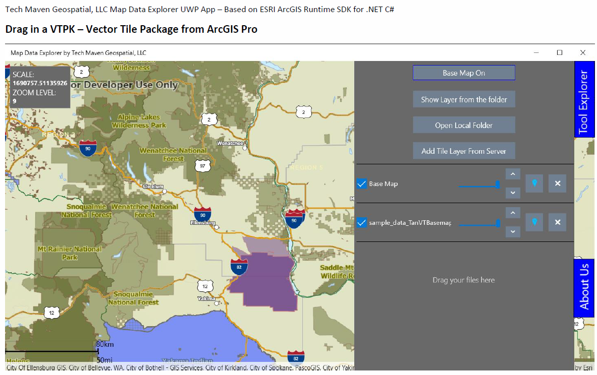
Load local Raster and Vector Data
TPK – Raster Tile Package
VTPK – Vector Tile Package
GPKG – OGC GeoPackage Raster Tiles and Vector Features
TIF, SID, JP2 Raster Imagery
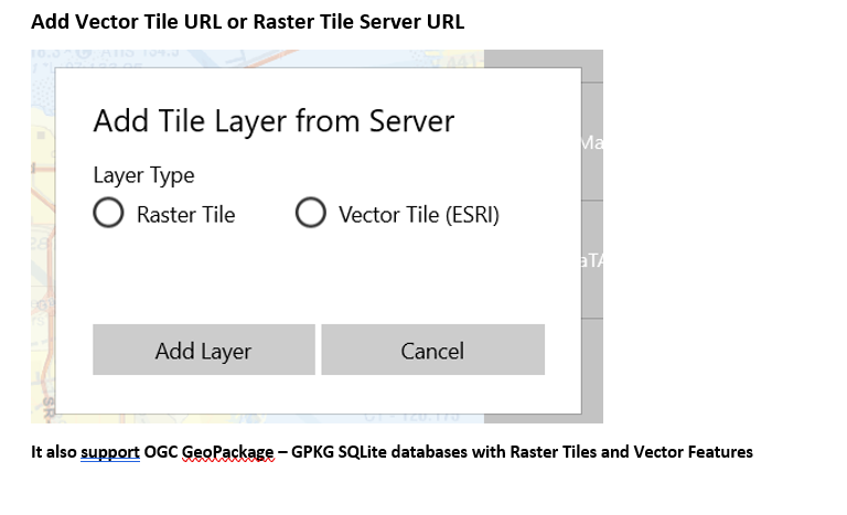
Load Tile Server URL’s
Raster Tiles
ESRI Vector Tiles with Style